Where can you check the Da Lat cloud-hunting forecast for the next 7 days?
If you only have one free morning, check the forecast score and choose a viewpoint you can reach mostly by road. If you're spending several days in Da Lat, compare the whole week and save your early start for a more promising morning.
By Da Lat LoversPublished Updated

A cloud-hunting trip in Da Lat can start more than an hour before sunrise, but thick fog at the top of a hill may leave you staring at a white wall instead of a valley filled with clouds. The cloud-hunting forecast tool compares weather conditions over the next seven mornings at six locations, assigns each a score from 0 to 100, and estimates when you should leave central Da Lat. You can use it to choose a morning and a viewpoint without assuming that a cloudy weather forecast guarantees a sea of clouds.
Free tool · hourly forecast data
Will there be clouds tomorrow morning?
A 0-100 score for the sunrise window at 6 cloud-hunting spots, built from forecast humidity, dew point, wind, low cloud and visibility. A high score combines several weather factors; it does not mean every condition is good and it is not a promise of clouds, so check wind and rain separately.
The 6 spots in this tool
Cau Dat tea hills
Elevation 1,599 m · From center ~25 km · Drive close
The busiest spot; a long, unlit ride; wooden-deck cafés charge for service. After rain, check the final access road first.
Da Phu hill
Elevation 1,584 m · From center ~10 km · Drive close
Close, free, a steep dirt walk at the end; slick after rain.
Du Sinh hill
Elevation 1,542 m · From center ~5 km · Drive close
Closest and lowest; better for thin mist than a thick sea of clouds.
Pinhatt peak (Tuyen Lam Lake)
Elevation 1,691 m · From center ~7 km · Long hike
About a 3-hour hike on a rough trail; go with a local guide.
Radar peak (Langbiang)
Elevation 1,929 m · From center ~12 km · Park with opening hours
The park opens at 7:30am, so there are no jeeps up to the peak at dawn.
Nui Ba summit (Langbiang)
Elevation 2,167 m · From center ~12 km · Long hike
The highest of the six, but a 3-hour night climb; check with Bidoup - Nui Ba National Park or the operator that the trail is permitted that day.
How we calculate the score
- Time window: from 60 minutes before to 90 minutes after sunrise, using the hourly forecast points inside it.
- Moisture (35 pts): an average temperature-dew point gap of 1°C or less scores full marks, 4°C or more scores zero, linear in between.
- Calm air (25 pts): average 10 m wind of 5 km/h or less scores full marks, 20 km/h or more scores zero.
- Cloud/fog signal (40 pts): the higher of peak low-cloud cover and a fog level derived from visibility (1 km or less = 100%, 10 km or more = 0%).
- Minus 15 if 0.5 mm of rain or more falls in the window; minus 10 if average mid-level cloud is 70% or more (a grey sky above).
- The viewpoint’s height above the model grid cell is shown for reference only and adds or removes nothing: Open-Meteo returns the cell’s average terrain height, not the height of the fog top, so the comparison cannot tell whether you will stand above or inside the fog.
- Bands: 70+ is “Favorable weather signals”, 45-69 “Mixed signals”, below 45 “Weak signals”. The thresholds have not been checked against real mornings.
- The best-signal box and the main ranking only include drive-up spots. Night-hike spots and Radar peak (the park opens at 7:30am) sit in a separate group.
Leave-the-center time (Xuan Huong Lake) = sunrise minus 20 min (arrive at first light), minus riding time (distance divided by 30 km/h), minus parking and walking time. It is shown as a 15-minute range because the distances and walking times are estimates.
Weather models use grid cells a few kilometers wide, so nearby spots can get the same cloud, wind and visibility data. The thresholds are our own choice and will be tuned with feedback.
Weather data: Open-Meteo.com (CC BY 4.0). Coordinates: © OpenStreetMap contributors. For guidance only, not a substitute for official weather warnings.
How to check the Da Lat cloud-hunting forecast for the next 7 days
The tool uses hourly weather forecasts to assess conditions around sunrise. Each location receives an overall score, accompanied by information about humidity, wind, low clouds, visibility, and precipitation.
You won't need any meteorology to use it. Start by finding a morning with a reasonably good score, then check the weather details and access conditions before making plans.
Step 1: choose a date under "Choose a morning"
Scroll to "Choose a morning", where you'll find options labeled "This morning", "Tomorrow", and the remaining dates in the seven-day forecast.
Each date button displays a number: the highest score among the drive-up spots. It isn't the average forecast score for Da Lat, and it isn't your percentage chance of seeing a sea of clouds.
Say Friday shows 76 points and Saturday shows 53 (made-up numbers, just to show how the scores read). Friday is worth checking first, but hold off on booking transport. The 76 might belong to a spot farther from your hotel, or one with wind and rain that make the trip less attractive.
On a three-day, two-night trip, compare the mornings before you plan the sightseeing. Save the most promising one for cloud hunting and use a weaker morning for sleeping in or for attractions that open later.
Step 2: check "Best signals in the next 7 days"
The tool includes a section called "Best signals in the next 7 days (drive-up spots)". It highlights a promising morning and location within the drive-accessible group, and it's the quickest place to start when you don't want to compare every date by hand.
The recommendation leaves out mountain summits that need long hikes and tourist attractions that aren't open at sunrise. That matters for ordinary visitors: a high summit might have favorable weather, but it's not a practical destination when you have one free morning, no hiking guide, and no experience walking mountain trails in the dark.
"Best" here means the strongest weather signal the tool calculated, not a confirmed sea of clouds.
Step 3: read the card for each spot
Once you've chosen a morning, read the card for the viewpoint you're interested in under "Drive-up spots" or in the separate group of night-hike spots and parks below it.
Each card shows:
- Elevation, next to the spot's name.
- Sunrise time.
- Suggested departure time under "Leave the center".
- "Temperature at dawn", with a "what to wear?" link.
- Wind, humidity, and the temperature-dew point gap.
- Low cloud and visibility.
The most useful details are sunrise time, suggested departure time, wind, rain, and visibility. For Cau Dat, Da Phu, Radar, and Nui Ba, the "See spot" link on the card opens that place's introduction. Check the temperature too: standing on an exposed hill before sunrise can feel considerably colder than walking around the city center in the afternoon.
Look past the top-scoring location, too. When two viewpoints are a few points apart, the closer one with easier access and kinder wind and rain is often the better morning out.
Step 4: check the "7-morning score grid"
To compare the entire forecast period, use the "7-morning score grid". It's far easier than opening individual dates and trying to remember their scores. Look for promising mornings during your stay, then pick those dates under "Choose a morning" to read the spot cards.
You don't need the highest-scoring morning of the entire week if it means a rushed itinerary. To take another made-up example, a 72-point morning with convenient transport may work better than a 78-point morning that means a much longer journey or disrupts the rest of your plans.
What does a cloud-hunting score from 0 to 100 actually mean?
The 0-100 score combines several weather conditions associated with low clouds or fog around sunrise.
Its three classifications are:
| Score | Label | Meaning |
|---|---|---|
| 70-100 | Favorable weather signals | Worth checking the details |
| 45-69 | Mixed signals | Compare other locations or keep a backup plan |
| Below 45 | Weak signals | Avoid high expectations based on the forecast alone |
These are categories defined by the tool, not independently validated meteorological standards for cloud hunting in Da Lat.
Even with a score of 85, you might find yourself standing inside thick fog, unable to see the valley below. A high score means that several conditions line up with the tool's scoring model, not that you'll get the view you're hoping for.
What time window does the score cover?
The tool assesses hourly forecast data covering the period from 60 minutes before sunrise to 90 minutes after sunrise. With sunrise at 5:45 AM, for example, the window runs from 4:45 AM to 7:15 AM.
This is not an all-day forecast. The sky might be cloudy at 5 AM and clear shortly after 7, or fog could cover the hills through the early morning and be gone by midday.
Because cloud hunting depends heavily on conditions around sunrise, hourly forecasts are more useful than a single weather icon representing the entire day.
How is the score calculated?
The tool awards points for three groups of weather conditions and applies deductions for certain unfavorable factors.
| Component | Maximum points | What it measures |
|---|---|---|
| Humidity and temperature-dew point difference | 35 | How close the air is to saturation |
| Calm wind | 25 | Lower average wind speeds receive more points |
| Low clouds or fog signal inferred from visibility | 40 | Low-cloud cover and reduced visibility |
| Rainfall of at least 0.5 mm | Minus 15 | Penalty when rainfall reaches the threshold |
| Mid-level cloud cover of at least 70% | Minus 10 | Penalty for extensive mid-level cloud cover |
Humidity contributes up to 35 points. When the average difference between air temperature and dew point is no more than 1°C, this component receives the full score. A difference of 4°C or more receives zero points, with values in between scored proportionally.
Dew point is the temperature to which air must cool to become saturated with water vapor, assuming other conditions remain unchanged. A small gap between temperature and dew point means the air is close to saturation, but it doesn't prove that a visible sea of clouds has formed.
For wind, the tool uses average wind speed at the standard measurement height of 10 meters. Wind speeds of 5 km/h or less receive the full 25 points for this component, and speeds of 20 km/h or higher receive zero.
The remaining 40 points come from low-cloud or fog signals. The tool uses the higher of two indicators: the maximum low-cloud cover percentage or a fog signal inferred from visibility. Visibility of 1 km or less corresponds to the strongest fog signal, while visibility of 10 km or more corresponds to the weakest.
Poor visibility may indicate fog, but thick fog at your viewpoint is not the same thing as a cloud layer spread out below you.

Why should you check wind and rain separately?
Imagine a viewpoint with very high humidity and extensive low-cloud cover. Those two components could contribute most of the total score even when the wind is relatively strong. Similarly, the rainfall penalty reduces the score but doesn't remove a location from consideration.
So a score of 70 or above is a cue to read the detailed forecast, not to arrange transport straight away. Unfavorable rain, or wind that seems too strong for an exposed hill, is reason enough to pick another morning. And the label "Favorable weather signals" is not a guarantee of dry weather, safe access, or good visibility.
Which of the six Da Lat cloud-hunting locations should you choose?
No single location offers the best cloud-hunting conditions every morning. Cau Dat has broad tea-growing hills and valley views, Da Phu is closer to the center, and Du Sinh is closer still, although the tool doesn't identify a fully verified viewpoint there.
These three are the drive-accessible spots. Pinhatt, Radar Peak, and Nui Ba have different access requirements and need to be considered separately.
| Location | Approximate elevation | Distance from center | Access category |
|---|---|---|---|
| Cau Dat tea hills | 1,599 m | 25 km | Drive close |
| Da Phu hill | 1,584 m | 10 km | Drive close |
| Du Sinh hill | 1,542 m | 5 km | Drive close |
| Pinhatt peak (Tuyen Lam Lake) | 1,691 m | 7 km | Long hike |
| Radar peak (Langbiang) | 1,929 m | 12 km | Park with opening hours |
| Nui Ba summit (Langbiang) | 2,167 m | 12 km | Long hike |
Elevations and distances are approximate reference values from the tool, not guaranteed distances to parking areas, passenger drop-off points, or individual viewing platforms.
Cau Dat tea hills: for wider valley views
1,599 m - 25 km - Drive close

Cau Dat is approximately 25 km southeast of central Da Lat. It suits travelers with early-morning transport who want to look across tea plantations, hills, and valleys.
There's no single viewing spot here. Wooden viewing structures, photography platforms, cafés, and other tourist services may operate under separate opening hours and admission arrangements. The forecast score describes weather conditions in the area; it doesn't confirm that every viewing platform will be open or positioned above the cloud layer.
Cau Dat is also a longer journey than the other drive-accessible options, so allow time to find the correct entrance, park, and walk to your chosen viewpoint. After rain, check the condition of the final access road before leaving.
Cau Dat scoring only slightly higher than Da Phu rarely makes the extra travel time worthwhile.
Da Phu hill: for a shorter journey
1,584 m - 10 km - Drive close
Da Phu is approximately 10 km from central Da Lat, a good fit for visitors who want to see sunrise without spending too much time traveling.
You can drive relatively close, although reaching some viewing areas involves walking along steep dirt paths. These get slippery after rain, especially before daylight.
The hill itself has no admission fee, though some of the surrounding paths and land may not be open to visitors.
First-timers should find out where to park and how to reach the viewpoint before setting off. Don't take an unfamiliar shortcut because your navigation app shows a shorter route.
For anyone staying in central Da Lat, Da Phu is one of the first places to check, provided the forecast is good and access is reasonable.
Du Sinh: close to the center, but check the exact viewpoint
1,542 m - 5 km - Drive close
Du Sinh is approximately 5 km from the city center, the closest of the six forecast locations, which helps when your schedule is tight. Getting to the Du Sinh area is the easy part; finding a clear, accessible place overlooking a sea of clouds is another matter.
The tool uses coordinates in the Du Sinh residential area as a weather reference point, not a confirmed scenic viewing platform.
Its reference elevation is also lower than those of Cau Dat and Da Phu. Du Sinh works when you want a shorter outing or hope to observe early-morning mist, but the actual view depends on where you stand.
Know your access route before you go, so you're not searching for any open patch of hillside before sunrise.
Pinhatt and Nui Ba: not last-minute alternatives
1,691 m and 2,167 m - Long hike
Pinhatt Peak overlooks the Tuyen Lam Lake area and has a reference elevation of around 1,691 meters. Although it's only about 7 km from the city center on the map, reaching the summit requires a substantial mountain hike that can take around three hours.
Nui Ba, in the Langbiang area, rises to approximately 2,167 meters and also requires several hours of hiking.
Both are classified as "Long hike" and aren't included in the tool's main recommendations for visitors who want to drive close to a viewpoint.
Reaching either summit for sunrise takes a separate trekking plan, confirmation of permitted access routes, and an appropriate local guide or organizer. For Nui Ba, check the applicable hiking and access rules with Bidoup - Nui Ba National Park or the relevant route operator before your trip.
A favorable forecast score isn't a reason to start an unplanned night hike.
Langbiang Radar peak: opening hours matter
1,929 m - 12 km - Park with opening hours

Radar Peak is approximately 1,929 meters above sea level and belongs to a tourist attraction that opens at 7:30 AM, so the regular visitor jeeps don't take anyone to the summit at the usual sunrise time.
Radar Peak stays in the six-location weather comparison, but it's left out of the main drive-accessible sunrise recommendation. Whatever its score, don't count on booking a jeep up at 5 AM.
What time should you leave for cloud hunting in Da Lat?
Departure times change with the date and the location, so look for "Leave the center" on the card of your chosen viewpoint.
The tool calculates a suggested departure time using sunrise, estimated driving time, parking, walking, and a buffer for arriving early. It starts with sunrise time, subtracts 20 minutes, and then subtracts the estimated travel and preparation time. Driving time is estimated using an average speed of 30 km/h, with additional time allowed for reaching the actual viewing spot.
The result is shown as a 15-minute departure window rather than an exact minute.
Why arrive before sunrise?
You can enjoy the scenery well before the sun appears above the horizon. The light begins changing before sunrise, while fog and low clouds may shift quickly as the ground warms.
Arriving about 20 minutes early gives you time to reach a suitable position and see what conditions are like. That's the tool's preparation buffer, not a rule that the best cloud scenery appears exactly 20 minutes before sunrise. The spare time matters even more at spots with a long walk from the parking area or lots of visitors.
What time should you leave central Da Lat?
Many early-morning cloud-hunting trips require leaving central Da Lat around 4-5 AM, depending on the destination and date.
Take a morning with sunrise at 5:45 AM.
Cau Dat is about 25 km away, roughly 50 minutes of driving at the tool's assumed average speed of 30 km/h. Add the early-arrival buffer, parking, and walking, and you may need to leave before 4:30 AM.
Da Phu is about 10 km away, so the driving portion takes around 20 minutes under the same assumption, plus time for parking and walking up the dirt paths.
Du Sinh is closer, but you'll need to identify your exact viewing location before deciding when to leave.
These examples explain the calculation. They aren't substitutes for the departure time shown by the tool for your selected day.
What if your hotel is far from Xuan Huong Lake?
The tool uses the Xuan Huong Lake area as its central reference point and doesn't know where your hotel is.
Staying near Nguyen Chi Thanh Street or Hoa Binh Market means a different route from staying near Tuyen Lam Lake, and from a hotel on the western side of Da Lat, the drive to Cau Dat may be longer than the reference distance.
When arranging a driver, give your exact pickup address and agree on the departure time in advance. On a motorcycle, allow extra time to put on warm clothing, check the bike, and find your way out of your accommodation area.
Visitors unfamiliar with riding motorcycles at night should consider a car with a driver or an experienced rider. Anyone driving or riding independently needs a valid license for the vehicle and must comply with Vietnamese traffic regulations.
Which weather details should you check before going?
Once you've found a promising score and departure time, spend another minute reading the detailed weather information. The aim is to spot situations where the overall score looks encouraging but the morning itself might not be.
High humidity and a small dew point difference
High relative humidity, together with an air temperature close to the dew point, indicates that the air is approaching saturation. That's relevant when looking for fog or low clouds, but it doesn't tell you whether the fog is sitting in the valley or covering the viewpoint itself.
With very high humidity and visibility down to a few hundred meters, your viewpoint may be surrounded by thick mist. That's a very different morning from standing on a clear hill and looking down at a smooth layer of clouds, so higher humidity doesn't mean a better sea-of-clouds view.
Calm wind helps, but it's not the whole picture
The tool gives the maximum wind component score when average wind speed is no more than 5 km/h.
Calm air can help some types of near-surface fog persist. Airflow in mountainous terrain, though, is more complicated than a single average wind-speed reading. Wind on an exposed ridge may be stronger than in an area sheltered by pine forest, and model data can't replace observing the wind at the actual viewpoint.
If the forecast indicates strong winds or dangerous weather, stay away from steep edges, however good the photo angle looks.
Low clouds and visibility are easy to misinterpret
In Open-Meteo's data, the low-cloud category covers clouds and fog in the lower atmosphere, up to roughly 3 km in altitude.
Extensive low-cloud cover points to potentially relevant cloud conditions, but it doesn't tell you exactly where the top of the cloud layer is relative to your viewpoint. Visibility has similar limits: a drop may come from fog, low clouds, or other factors affecting how far you can see.
A morning with extensive low cloud might produce an impressive valley scene. But if the same cloud layer surrounds the hilltop, you may see nothing but white mist.
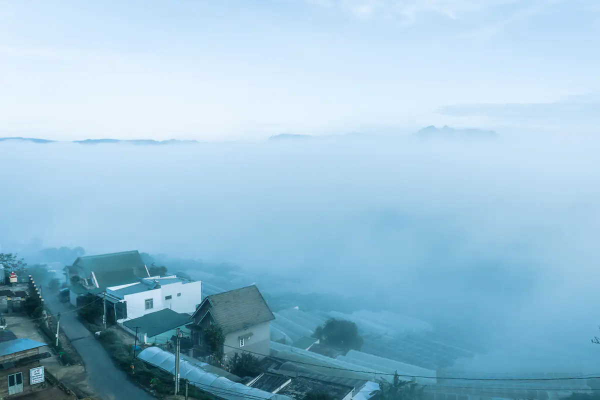
That's one reason two viewpoints with identical 75-point scores can offer completely different scenery.
Rain and mid-level clouds
The tool applies a 15-point deduction when rainfall within its evaluation window reaches 0.5 mm or more, and deducts 10 points when average mid-level cloud cover reaches at least 70%.
Extensive mid-level clouds may block some of the sunlight from above, so even with fog filling the valley, the morning can stay gray with little warm light passing through.
Rain also creates practical problems beyond photography. Dirt roads around Da Phu, access paths outside residential areas, and mountain hiking trails can become more difficult after prolonged rainfall.
The tool uses rainfall as a scoring factor. It does not assess road surfaces, landslide hazards, or temporary access restrictions. When hazardous weather warnings are issued, prioritize official meteorological information and instructions from local authorities.
How should you choose a morning if you're staying in Da Lat for several days?
Start with the mornings your itinerary actually allows, then compare scores and practical access.
If you're staying for just one night
You may only have one opportunity before checking out or continuing to another destination. Choose "Tomorrow", compare the scores for Cau Dat, Da Phu, and Du Sinh, then check the departure-time recommendation for each.
Weak signals at all three mean there's little reason to travel far just to tick cloud hunting off your itinerary. You could still visit an accessible viewpoint for sunrise, without expecting a sea of clouds.
On a favorable morning, prioritize a location with a clear access route and manageable travel time. Groups traveling with young children, or anyone uncomfortable with very early starts, should think carefully about walking unfamiliar paths before daylight.
If you have two or three mornings
This is where the seven-day forecast earns its keep. Check the "7-morning score grid", compare the dates available during your stay, choose a promising morning as your first option, and leave another morning relatively flexible, so a forecast change the evening before doesn't force you to cancel much else.
Say Monday shows 68 points and Tuesday shows 77, and you're in Da Lat on both days: look at Tuesday first. Rain on Tuesday plus slippery dirt roads at the viewpoint, though, and the nine-point difference stops meaning much.
Forecasts several days ahead can change, so don't pay for nonrefundable services because an attractive score appeared early in the week.
If you have a full week but only want one early start
Begin with "Best signals in the next 7 days" to identify the strongest signal among drive-up spots, then check the weekly comparison to see whether another morning has a similar score.
Three points between a 79 and a 76 matter less than whether the 76 lets you travel with friends, arrange transport more easily, and avoid changing accommodation. The score is one planning factor, not the only one.
Checking cloud hunting in Da Lat today: when should you refresh the forecast?
Hourly weather forecasts can change as new model data becomes available, so the result you saw several days ago may not match the one shown on the evening before your trip.
For a trip tomorrow morning, reopen the tool that evening and check the selected date, location, and important weather details.
Shortly before leaving, you can select "Reload" to request updated data. That's still forecast model data, not a live measurement from the hillside or a camera pointed at the cloud layer.
The "This morning" option is most useful before or around sunrise. Once 90 minutes have passed after sunrise, that date's button shows "passed" and can no longer be selected.
After a network error, tap "Try again" to request the data again. An older score isn't worth relying on if the tool hasn't loaded fresh information or you can't establish which time period the result represents.
Why can two nearby viewpoints receive the same forecast?
The tool obtains weather forecasts from Open-Meteo and uses OpenStreetMap for reference coordinates.
Weather models divide geographical areas into grid cells. The resolution varies by model, and individual cells can cover several kilometers or more, so two nearby viewpoints may receive identical wind, cloud, or visibility forecasts even though they overlook different valleys.
Da Lat's hills, ridges, slopes, and valleys sit close together. Changes in elevation, slope direction, and shelter from surrounding hills can affect local fog conditions, and a regional forecast model cannot reproduce every small difference.
Does a higher viewpoint receive a higher score?
No. Elevation is shown as reference information, but it isn't added to the scoring formula.
The elevation of the terrain represented by a weather-model grid cell also isn't the altitude of the top of a cloud or fog layer. You therefore cannot subtract the model's terrain elevation from the summit elevation and conclude that you'll be standing above the clouds.
A higher viewpoint can still lose out. On some mornings, fog settles in low-lying areas while hilltops remain clear. On others, cloud can cover the entire landscape.
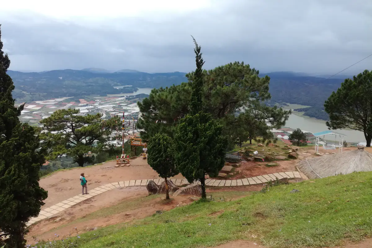
To know exactly what is happening, you need to be at the location at that time. The forecast score just narrows your choices before you leave.
How should international visitors and first-time travelers use the tool?
Anyone unfamiliar with Da Lat's terrain should start with the three "Drive-up spots". Cau Dat suits travelers with an early driver and enough travel time. Da Phu is a shorter journey, although access may include dirt slopes. Du Sinh is closer to the center, but you still need to confirm the exact place where you intend to watch the sunrise.
A higher forecast score isn't a reason to pick Pinhatt or Nui Ba. Those destinations require separate hiking plans and are not equivalent to an ordinary drive-and-watch-sunrise excursion.
When booking transport, confirm the actual destination, pickup time, drop-off point, walking distance, and what's included in the quoted price. Two services both advertised as "Cau Dat cloud hunting" may take visitors to different viewing locations.
International travelers should also check whether their driving licenses are legally valid for the vehicles they intend to operate in Vietnam. Anyone uneasy about riding a motorcycle on mountain roads before daylight is better off hiring a car with a driver.
It also helps to save your destination's Vietnamese name, hotel pickup location, and driver's contact details, which cuts the risk of confusion during a very early departure.
Deciding not to go can be a good use of the forecast
Not every morning with a forecast score is worth organizing a cloud-hunting trip. Weak signals everywhere, or a recommended viewpoint with access conditions that don't suit your group, are good reasons to skip the outing. Having already set an alarm is no reason to go looking for another unfamiliar hill in the dark.
Likewise, a high score accompanied by unfavorable wind or rain should encourage you to reconsider the route and check official weather warnings.
The tool cannot confirm whether a road is under repair, an entrance gate is locked, a hillside is private property, or a tourist attraction has changed its opening hours. Open-Meteo forecast data also doesn't replace official warnings issued by Vietnam's National Center for Hydro-Meteorological Forecasting.
Regular cloud hunters can record the forecast score before each trip and note what they actually saw. Over time, those notes may show how the score behaves at the locations you visit most often.
A few successful outings, however, don't establish that a score of 80 means an 80% chance of success. A reliable probability requires a sufficiently large set of observations and a clear validation method.
Three things to confirm before setting your alarm
After checking the forecast, you should have clear answers to three questions: which morning are you going, where will you stand, and what time will you leave your accommodation?
Your chosen date should have acceptable weather signals without wind or rain conditions that make the outing unsuitable. The destination needs a known access route that matches your group's mobility and experience. And your departure time should account for your actual pickup location, rather than relying only on distance from Xuan Huong Lake.
Anyone using a driver should confirm the schedule and meeting point the evening before. If you're traveling independently, prepare shoes with good grip, a windproof outer layer, a charged phone, and a reliable route back.
These preparations won't increase the forecast score. They just make the outing easier to manage, whether you find a sea of clouds or a foggy hillside.
Conclusion: which forecast view should you use?
One morning only: choose "Tomorrow", check the drive-accessible recommendations, and review wind, rain, and "Leave the center" before leaving. Several days in Da Lat: use the "7-morning score grid" to compare your options. A score of 70 or above deserves a closer look, but it is never a promise that you'll see a sea of clouds.
FAQ
Is cloud hunting in Da Lat worth trying today?
Choose "This morning" under "Choose a morning" to see forecast scores for the six locations. Before heading out, select "Reload" to obtain updated data and review wind, rain, and visibility. The score describes weather conditions around sunrise; it doesn't confirm that a sea of clouds is currently visible.
What time should I go cloud hunting in Da Lat?
Many cloud-hunting trips require leaving central Da Lat around 4-5 AM, depending on the date and destination. Check "Leave the center" for the suggested departure window, which accounts for driving, early arrival, parking, and walking from the Xuan Huong Lake reference area. Adjust the timing if your hotel is farther away.
What is the best month for cloud hunting in Da Lat?
Cloud and fog conditions vary by season, and no month guarantees a beautiful sea of clouds every morning. This tool doesn't rank the months of the year; it evaluates hourly weather conditions for the next seven mornings. Once you've chosen your travel dates, checking the forecast close to departure is more useful than relying on the month alone.
Where is the best place for cloud hunting in Da Lat?
The forecast tool doesn't rate scenic beauty. Among the drive-accessible locations, Cau Dat suits visitors looking for broad hill and valley views who don't mind a longer journey. Da Phu is closer to the city center, while Du Sinh requires extra care in identifying the actual viewpoint. Compare the weather scores for your chosen morning and select a location with suitable access.
Does a cloud-hunting score of 80 guarantee a sea of clouds?
No. A score of 80 combines humidity, the temperature-dew point difference, wind, and signals from low-cloud cover or reduced visibility, with deductions for rain and mid-level clouds. It isn't an 80% probability of seeing a sea of clouds. The score thresholds haven't been validated against enough real observations, and the tool cannot reliably determine whether the cloud layer will be above or below your viewpoint.